
Area archeologica di Santa Cristina - Paulilatino (Oristano)
Archaeological area of Santa Cristina
Type:
Luoghi della cultura; Oggetto fisico
Category:
Archaeological areas; Art museums
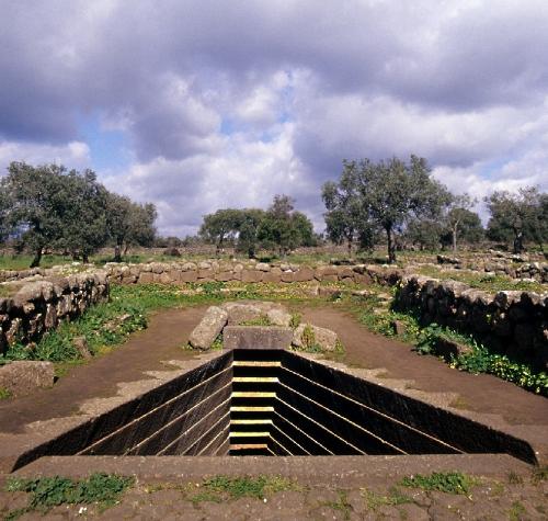
The archaeological site of Santa Cristina is characterised by two different areas: the Nuragic complex and the church dedicated to the Saint with the little houses (called cumbessias or muristenes) used to give hospitality to the pilgrims. The Nuragic complex consists of a well temple surrounded by the ruins of a Nuragic village and the nuraghe of Santa Cristina, with some remains of houses dating from different periods. Thanks to its refined building technique, the well temple of Santa Cristina is the most representative in Sardinia and dates back to the 11th-9th century BC. Built of basalt stone blocks, it is surrounded by a wall that delimits the elliptical sacred area (temenos). A flight of stairs leads to the bottom of the well, where spring water still gushes. Near the temple is the well- preserved meeting hut (14m long) with its perimetric bench, and some small huts. The nuraghe Santa Cristina is 200m far from here. It is a modest single-tower structure (6m high), built of rough-shaped stones. Nearby, two huts with well- preserved stone slabs roof are still visible.
Partially accessible to disabled people.
Condizioni d'uso della risorsa digitale:

Quest'opera di MetsTeca è distribuita con Licenza Con attribuzione, no opere derivate, senza riuso commerciale.
Is referenced by:
consulta la scheda dell'Anagrafe Luoghi della Cultura
see website
Sardegna Cultura
Portale Sardo
Provider
Anagrafe Luoghi della CulturaIdentifier: mus_7166
Rights
License: Con attribuzione, no opere derivate, senza riuso commerciale